
4D - Actionable Intelligence
In today’s increasingly interconnected world, system platforms involving multiple geographical sites, many sources of information and various areas of responsibility are more and more common. Therefore seamless integrations are needed for efficient operations such as crisis management, fight against crime or standard daily tasks.
The success of integrated platforms relies on the ability to anticipate and respond to events affecting multiple locations and areas of responsibility. At the same time a system platform should preserve the individual vision and responsibilities of the different stakeholders, keep control of information ownership and select and present only relevant information to the right operator.

TERRA 4D integrated solutions allows for:
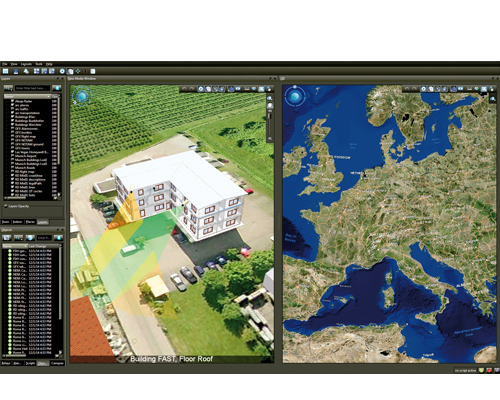
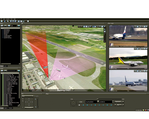
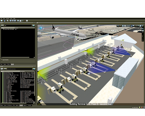
- Comprehensive operational picture based on 3D GIS model
- Geo-referencing existing and future data sources
- Selective data distribution on a need-to-know basis
- Access to data services (environment, intelligence,
weather, news ...) - Improved notice, response and incident resolution
- Greater efficiency and cost savings
- Improved situation response times and minimized risk
TERRA 4D. Win!
The requirement for organizations to provide continuously improving, cost-effective security solutions needs a new geospatial approach to manage large amount of information and present it to security control rooms in geographical context. The advanced geospatial analysis of TERRA 4D evaluates every single incident and assists through guided workflows offering a unique situational awareness for operators.
TERRA 4D provides tools that significantly accelerate response, improve efficiency and reduce operating costs in every phase of the situational management lifecycle. TERRA 4D is vendor independent and supports crossplatform interoperability. The common unified user interface allows remote control of platforms, sensors and subsystems including air, land, maritime and space-based platforms.

Multi-Sensor Geospatial Data Fusion
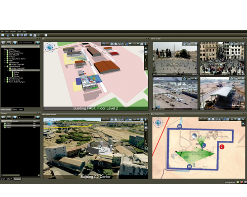
Many sources, one platform. TERRA 4D doesn’t just bring data together, it helps operations manage incidents from start to finish. Intuitive, clearly represented and accurate, this is new dimension security.
The TERRA 4D system combines and cross-references events from several subsystems or sensors to verify alarm conditions. Any incident or system event can trigger a preprogrammed event handler. Operator instructions, multi sensor correlation for alarm verification, automated object tracking and many more options are available to define the appropriate system reaction to a foreseen event.
Alarm and warning zones are defined centralized in the 3D GIS model. No matter what sensor type (e.g. video motion detection ...) has signaled the Avatar to enter a zone – an event is triggered immediately. Use geo-fencing in combination with alarm and warning zones to detect early threats and enable proactive actions. Multi camera auto tracking is available to verify type of treat or to improve object classification.


TERRA 4D Platform
Terra 4D is a software platform designed to integrate multiple unconnected security and safety applications and devices and control them through one comprehensive user interface.
TERRA 4D is vendor independent and supports crossplatform interoperability. The common unified user interface allows remote control of platforms, sensors and subsystems including air, land, maritime and space-based platforms.
The innovative software platform which immediately takes you to the next dimension in security management. It solves any unanswered questions related to your security and safety.
Why settle for less?
Objective. Intuitive.
Greater overview, quicker response, this intuitive system makes it possible. Behind this is a clever system architectural design – which leaves no question unanswered.
- Scaleable from compact version on a single computer to complex, worldwide distributed solutions
- Support of multiple site operations
- Autonomous site operation in case of site isolation
- Redundancy for every crucial part to avoid single points of failures
- Designed to receive, analyze, visualize in 3D, retrieve and securely share data across multiple agencies and users
- Reliable and secure architecture consisting of management server, acquisition server and operator’s client workstation
- The management server hosts all system wide information and controls the whole installation
- The acquisition server manages the configuration of the peripheral devices and controls the device status permanently
- Features like centralized user access management, cross client chatting, selective data exchange across all users supported

Client
- Command and control center
- Mobile clients
- Seamless access to all sites
Master Server
- Manage configuration
- User Management
- Alarm Management
AQ Sever 1 … N
- Collect sensor data
- Configuration of subsystems
- Track sensor status
Databases
- Cfg DB: Configuration data
- Inc DB: Incidents reporting
- Rec DB: Sensor data recording
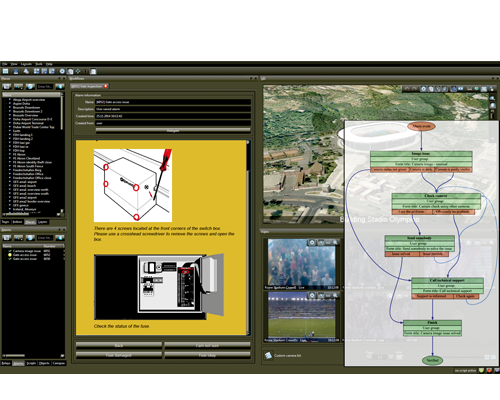
Incident Workflow
With TERRA 4D you can reduce the risk of human error, improve security response, protect existing security investments and reduce operating costs by converging all your security cameras, sensors, subsystems, data sources and operating procedures into a single unified and structured platform.
A software platform designed to integrate multiple unconnected security and safety applications and devices and control them through one comprehensive user interface.
The TERRA 4D incident workflow chart represents state of the art security and safety event processing.
TERRA 4D solutions offer advanced features that support security operators to assess and resolve incidents efficiently. Features like multiple camera object tracking, time machine, workflow and incident reporting, localization and dispatching are a few of many helping operators to react immediately and efficiently on security incidents. Thanks to the 3D GIS model the intuitive and field-approved user interface provides superior situational awareness in all circumstances.

Dashboard
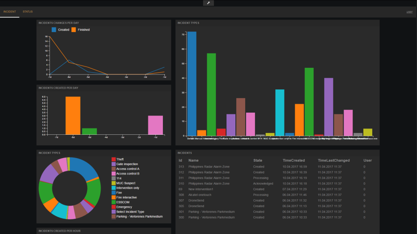
The Dashboard module in TERRA 4D provides a high-level overview of all system elements in configurable and individual layouts based on panes. The user depended layouts provide a quick summary of the system / operator performances and incident statistics. Dashboards are based on HTML5 / Java Scripts and run in the web-browser.
The Dashboard is usually displayed on dedicated screen(s) on the command and control center video wall. In addition it can be shown on iOS and Android tablets and similar mobile clients.
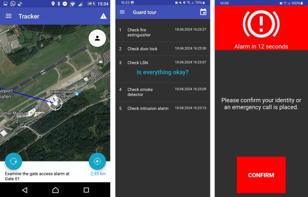
Tracker App
The Tracker App is the mobile add-on to TERRA 4D. It connects mobile forces with operators in control rooms for efficient collaboration and communication. It’s the ultimate tool for superior situation awareness and exchange of critical real-time information:
- GPS position tracking of mobile field devices
- Navigational support to find target position
- Receive target coordinates from operator including text message
- Raise different alarm events and send to operator in control room
- Exchange messages and pictures between TERRA 4D Tracker App and command and control
- Send and receive messages and images from operator to intervention team members
- Fill interactive incident reports within the Tracker App and share the reports with the operator in command and control
- Dead man function
- Guard tour including time and route deviation